Geosite · La Cierva
Las Hoyas
Las Hoyas, in La Cierva, around 20 km from Cuenca, is one of the most important sites for studying the Lower Cretaceous because of its fossil preservation. The regional government of Castilla-La Mancha describes it as a subtropical freshwater wetland from the Barremian, around 125 million years ago. It has been a Bien de Interés Cultural (Spain's highest heritage listing) since 2016.

- Municipality
- La Cierva
- Palaeontology
- Cretaceous
- Las Hoyas
- La Cierva
- Fossil birds
A wetland from 125 million years ago
Las Hoyas is in the municipality of La Cierva, around 20 km from Cuenca. Its rocks date from the Lower Cretaceous, around 125 million years ago. There was then a subtropical wetland here, a network of lakes and pools of lime-rich water resembling the Lagunas de Ruidera, with a wet season and a dry season. Land and water creatures lived together, groups that became extinct and ancestors of today’s species. It is a natural laboratory for seeing how the groups of plants and animals now dominating the planet emerged.
Exceptionally preserved fossils
What makes the site unique is how its fossils are preserved. There is a fern, Cladophlebis; an insect, Iberonepa romerali; a shrimp, Delclosia martinelli; a frog, Gracilibatrachus; the bird Eoalulavis; the dinosaur Pelecanimimus; the fish Rubiesichthys; the mammal Spinolestes; and shoals of young fish that died suddenly. It is compared with Yixian, in China, of the same age, and Messel, in Germany. In 2026 another bird, Gorgonavis alcyone, was described from an incomplete skull. A team from the Universidad Autónoma de Madrid has studied it for more than thirty years.
It has been a Bien de Interés Cultural, as a palaeontological zone, since 2016.
Some façade slabs
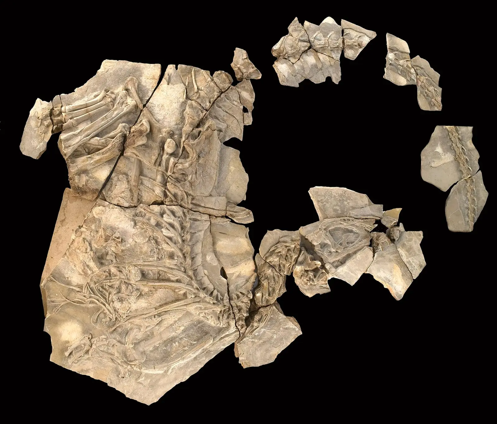
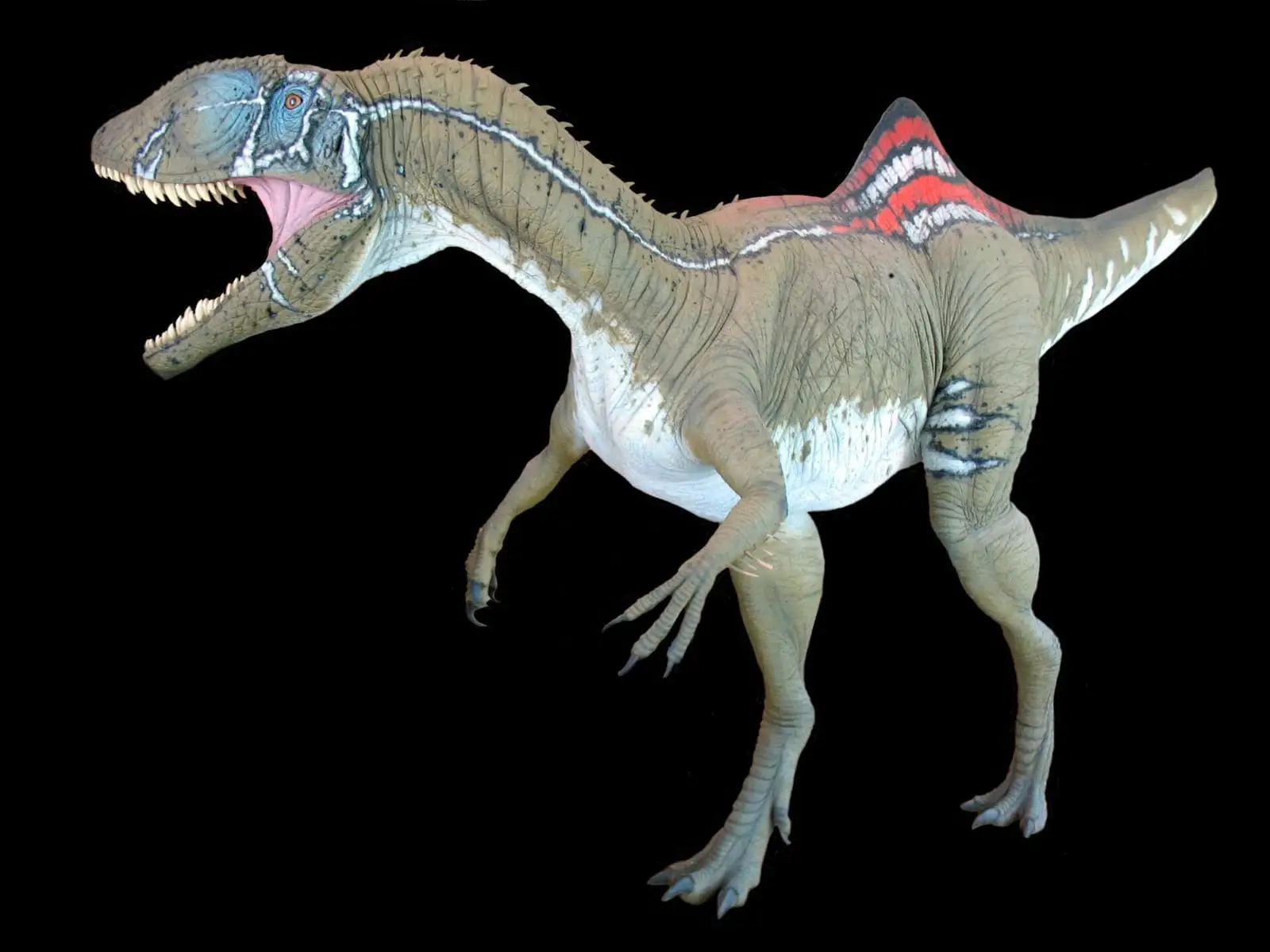
Las Hoyas was discovered through a wall. In the 1980s, a builder friend of the Cuenca geologist Santiago Prieto showed him fossil fish in limestone slabs he was using to clad houses; they came from a slope disturbed for pine planting, where machinery had left heaps of stone. Prieto went to the site and took a few samples to the university in Madrid. There, in Professor Nieves López’s office, he met palaeontologist José Luis Sanz, who took charge of the research. Armando Díaz Romeral also appears alongside him among those who brought the site to public attention. The first field season was in 1988, according to a radio interview with Sanz; another item from the same station refers to excavations since 1985. Some large remains of Concavenator were already among the samples from the 1980s, encased in rock, but the skeleton was not excavated until 2003 or described until 2010.
How the work is done
Each summer, students from the Universidad Autónoma de Madrid split the limestone layers with small cold chisels and examine what is inside each one. Anything of interest is recorded with its layer, because what matters is knowing how organisms change from one level to another, and taken to the museum to be cleaned, repaired and catalogued. Not everything is spectacular: a small mark may be a coprolite, fossilised excrement that may one day reveal what its producer ate. In a trench called Magenta, a long trackway was studied in 2021, left by a theropod dinosaur two or three metres tall with a slight limp: one toe was turned backwards. The footprints survived in such detail because they fell on microbial mats that hardened the mud almost immediately. Around thirty people from several countries worked in the 2026 field season; besides searching for fossils, they mapped the terrain to establish the extent of the ancient wetland, analysed samples at Barcelona’s ALBA synchrotron and began gathering data so that a doctoral thesis on artificial intelligence might one day help study them. The full story is told in Las Hoyas, from a wall to a fossil site.
Palaeontologist and illustrator Óscar Sanisidro, who chose Concavenator as the main subject of his Dinoguía de la península Ibérica (Anaya, 2024), explains how a dinosaur is drawn: like a dissection in reverse, from skeleton to muscles and then skin, grounding every decision in published data. Gaps in the fossil are filled by comparison with its relatives, and that is an inference, not something preserved: colour, for example, has only been studied in a few exceptional fossils from China. A drawing of Concavenator is not a photograph. Nor did it live alongside the animals of Lo Hueco: Las Hoyas is around fifty million years older.
Plan your visit
The fossils can be seen at the Museo de Paleontología de Castilla-La Mancha, in Cuenca.
Before you travel
The site cannot be visited independently. Only students and researchers may enter, by requesting access from the museum at least 15 working days in advance; entry is free. Nothing may be collected or excavated outside the scientific teams.
Combine with
The village of La Cierva and the landscape of Tierra Muerta.
Frequently asked questions
What has been found?
The IGME highlights birds, small dinosaurs and early flowering plants. In 2026 Gorgonavis alcyone, a bird, was described from a fragmentary skull.
When was it listed as a BIC?
The Governing Council declared it a BIC in the Palaeontological Zone category on 15 March 2016.
Carry on from here
Lands and landscapes
From here, follow the memory of the land
These readings connect Las Hoyas with the stories, the work and the villages around it.
This place through time
Which eras you can read here
A single place can keep traces of several periods. These layers connect what you see with the atlas's stories.
Where it is
● Reference point · ● Villages · ● Places · ━ Routes nearby
Location sketch. The map with paths and names loads as you scroll to it.
Reference villages: La Cierva · Valdemorillo de la Sierra · Valdemoro-Sierra · Cañada del Hoyo.
Open the full map and its historical layers →More geology and karst landscapes nearby
See all →


Where the data on this page come from
- Name
- Rewilding España source consulted, 4 October 2026
- Junta de Comunidades de Castilla-La Mancha source consulted, 4 October 2026
- Junta de Comunidades de Castilla-La Mancha source consulted, 4 October 2026
- Junta de Comunidades de Castilla-La Mancha source consulted, 4 October 2026
- Junta de Comunidades de Castilla-La Mancha source consulted, 4 October 2026
- Junta de Comunidades de Castilla-La Mancha · Portal de Cultura source consulted, 4 October 2026
- Consejo de Gobierno de Castilla-La Mancha: «Acuerdo de 15/03/2016 por el que se declara BIC el Yacimiento de Las Hoyas, con categoría de Zona Paleontológica [2016/3464]» (2016) source consulted
- «Las Hoyas» source consulted
- Nebreda, Sergio M. y otros: «An isolated skull from Las Hoyas (Early Cretaceous, Spain) informs the early evolution towards elongated rostra in enantiornithine birds (Aves, Ornithothoraces)» (2026) source consulted
- Municipality (INE code)
- Rewilding España source consulted, 4 October 2026
- Junta de Comunidades de Castilla-La Mancha source consulted, 4 October 2026
- Junta de Comunidades de Castilla-La Mancha source consulted, 4 October 2026
- Junta de Comunidades de Castilla-La Mancha source consulted, 4 October 2026
- Junta de Comunidades de Castilla-La Mancha source consulted, 4 October 2026
- Junta de Comunidades de Castilla-La Mancha · Portal de Cultura source consulted, 4 October 2026
- Consejo de Gobierno de Castilla-La Mancha: «Acuerdo de 15/03/2016 por el que se declara BIC el Yacimiento de Las Hoyas, con categoría de Zona Paleontológica [2016/3464]» (2016) source consulted
- «Las Hoyas» source consulted
- Nebreda, Sergio M. y otros: «An isolated skull from Las Hoyas (Early Cretaceous, Spain) informs the early evolution towards elongated rostra in enantiornithine birds (Aves, Ornithothoraces)» (2026) source consulted
- Location
- Rewilding España source consulted, 4 October 2026
- theme
- IGME: yacimiento paleontológico de Las Hoyas (IB216) source consulted, 9 October 2026
- tags
- IGME: yacimiento paleontológico de Las Hoyas (IB216) source consulted, 9 October 2026
«Source consulted»: the primary source has been read. «Reference located»: the source has been identified but not yet read. «Open question»: the figure needs confirmation.