Village · Cuenca
La Cierva
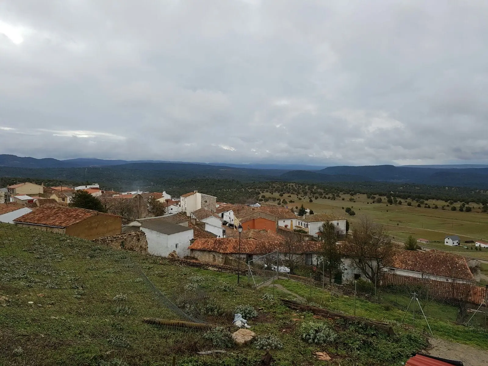
La Cierva is a village in the Serranía Media (middle Serranía) of Cuenca, about 50 km from the city, beside Tierra Muerta. Its municipality contains Las Hoyas, an Early Cretaceous site listed as a Bien de Interés Cultural since 2016, with fossils about 125 million years old. It had 458 inhabitants in 1877 and 34 in 2021; today only one woman sheep farmer remains.
On this page 11 sections
A hillside village beside Tierra Muerta
La Cierva lies in the Serranía Media, about 50 km from Cuenca, on a slope between two river plains and near Tierra Muerta. The municipality lies within the Palancares y Tierra Muerta Natural Monument and Valle del Cabriel Biosphere Reserve. It is a cold village.
Las Hoyas
Within the municipality is Las Hoyas, one of the most important places for studying the Early Cretaceous. About 125 million years ago it was a subtropical freshwater wetland, and its fossils preserve exceptional detail: birds, small dinosaurs, some of the earliest flowering plants. It has been a Bien de Interés Cultural (Spain’s highest heritage listing), as a Palaeontological Zone, since 2016.
It keeps producing news. In 2026 Gorgonavis alcyone was described, a bird known from an incomplete skull: the first adult bird skull remains of that age found in Europe. Las Hoyas fossils can be seen at the Museo de Paleontología de Castilla-La Mancha in Cuenca.
What trades and memory tell
A woman stockbreeder from La Cierva told Vestal Etnografía how the trade continued in her family and how the village went from several sheep flocks to her alone. Sheep were the basis of the mountain economy; their retreat forms part of Depopulation.
The road to the village ends there. Hence in August 1993 a German couple, a geologist and a teacher planning excursions round the Cañada del Hoyo lakes, came to see what lay at the road’s end. They arrived during festivities, villagers welcomed them and they returned each year; on retirement they stayed. In 2023 she was elected mayor of a village of 25 inhabitants, all over twenty, seeking a year-round bar and homes for young people. With tools found in the half-ruined house they bought and later donations, they opened a Museo de Usos y Costumbres in 2023: pack saddles and carrying frames, yokes and hames, threshing-floor shovels, wooden reaping finger guards, esparto tools, a well-used slaughtering bench, honey jars, grain measures and a bedchamber with bed, cradle and chest. Some women recognise utensils they used as girls.
Jasper for the cathedral and pines for the Navy
The municipality has about three jasper quarries, yellow and violet, with cut blocks left uncollected. This jasper was used in Cuenca cathedral in Ventura Rodríguez’s work, at the high altar and San Julián’s transparente, a light-admitting altarpiece structure; raw it looks grey, acquiring colour only when cut and polished, formerly in a cloister workshop. In the 18th century the best pines were marked in the king’s name for the Navy, for masts, rigging spars and deck beams, and went down the Cabriel towards the Mediterranean. The village historian links a consignment to the warship San Justo, present at Trafalgar. Another trade remained for the village: charcoal, sold in Cuenca.
An old boundary lawsuit held at the Real Chancillería de Granada recounts the village’s name: two men returning from Cuenca said the first settlers, colonists fleeing a bad lord, asked Cuenca council’s permission to settle and gave it a hind. This is tradition recorded in a lawsuit, not proof of the name’s origin.
Routes
The PR-CU 21 short-distance trail leads to Fuente de Marimingo: 8 km and about two hours. It opened in 2026.
Plan your visit
Start at the museum in Cuenca to see the fossils. Then the village and PR-CU 21.
Before you travel
Las Hoyas is a protected site: entry is only on visits organised by the regional government, and no fossils or stones may be collected.
Combine with
Valdemorillo de la Sierra is 6.3 km away as the crow flies and Valdemoro-Sierra 8.8.
Frequently asked questions
What is Las Hoyas?
An Early Cretaceous vertebrate site from a subtropical freshwater wetland about 125 million years old, in the Calizas de La Huérguina Formation. It has been a Bien de Interés Cultural in the Palaeontological Zone category since the agreement of 15 March 2016.
Which fossils stand out?
Birds, small dinosaurs and early angiosperms. In 2026 the skull of Gorgonavis alcyone, a long-faced enantiornithine bird, was described from a MUPA museum specimen.
What route is there in La Cierva?
PR-CU 21, Ruta de la Fuente de Marimingo: 8 km, 150 m of elevation gain and about 2 hours.
Carry on from here
The rivers, zones, eras, places and official routes that the atlas links with La Cierva.
Lands and landscapes
From here, follow the memory of the land
These readings connect La Cierva with the stories, the work and the villages around it.
Traces in the village and around it
Which eras you can read here
A single place can keep traces of several periods. These layers connect what you see with the atlas's stories.
Places in the municipality and around it

Official routes
Near La Cierva

Beamud viewpoint
Beamud
Fuente de los Pastores picnic area
Beamud
Fuente de la Ardilla picnic area
ValdemecaSee 5 more

Prao de San Roque picnic area
Huerta del Marquesado
Fuente del Royo picnic area
Huerta del MarquesadoPaisaje Ilustrado of Huerta del Marquesado
Huerta del Marquesado
Fuente del Arenazo picnic area
Cuenca
Molino de Juan Romero picnic area
CuencaPopulation of La Cierva, 1842–2021
La Cierva reached 458 inhabitants in 1877. The 2021 census counted 34, 93 % fewer. It is the story told in the emptying.
Climate in La Cierva month by month
Averages for the ten years from 2015 to 2024 from the ERA5 reanalysis (Copernicus), for a grid cell with a reference altitude of 1238 m. They are model estimates, not measurements from a local station or thirty-year climate normals.
Source: Copernicus ERA5 via Open-Meteo, CC BY 4.0. Retrieved: 2026-10-09.
Location
● Reference point · ● Villages · ● Places · ━ Routes nearby
Location sketch. The map with paths and names loads as you scroll to it.
Approximate position: village centre.
Reference villages: Valdemorillo de la Sierra · Valdemoro-Sierra · Cañada del Hoyo · Pajarón.
Open the full map and its historical layers →Where the data on this page come from
- Location
- IGN: Nomenclátor Geográfico Básico de España, capital de municipio (CC BY 4.0) source consulted, 9 October 2026
«Source consulted»: the primary source has been read. «Reference located»: the source has been identified but not yet read. «Open question»: the figure needs confirmation.