Village · Cuenca
Zafrilla
Zafrilla is one of Castilla-La Mancha's highest villages: over 1,400 metres, in the far east of Cuenca province, beside the Aragón boundary and in the Montes Universales area. Two approved trails climb its valley to over 1,500 m. It reached 952 inhabitants in 1910 and had 56 in 2021.
On this page 7 sections
A village on high ground
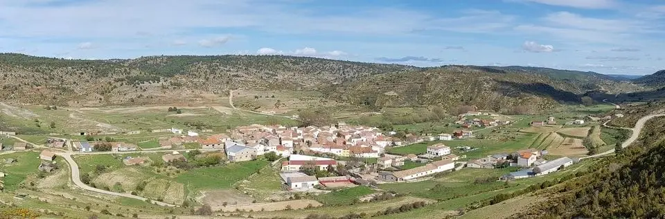
Zafrilla lies in the province’s far east, above 1,400 metres and very close to Aragón, in the Montes Universales, where the Serranía de Cuenca meets the Teruel ranges. Scots-pine and maritime-pine woods and open plateaux surround it, and part of the municipality lies in the Natural Park and Valle del Cabriel Biosphere Reserve. Houses are stone-built, with pitched roofs for snow; the church is San Andrés. Festivities take place in summer.
It was a livestock village. Around 1850, Madoz counted about 8,000 head of sheep and goats and 400 mares and cattle in Zafrilla, and trade consisted of selling sheep and cattle. The Town Council, with a budget of 2,700 reales, was funded by the bread oven, a flour mill and a municipal pasture.
Routes
Both trails follow the Zafrilla river.
- PR-CU 16 (short-distance trail), Sendero de la fuente del Tejo: 17 km. It leaves over the medieval bridge, climbs a bridle path to El Yesar and follows tracks above 1,500 m to near Morrón Blanco. It descends, crosses the river to the former Collado Verde de Arriba hamlet and returns along the valley to the Fuente del Tejo picnic area.
- PR-CU 113, Ruta cicloturista de Zafrilla: 28 km, intended for mountain bikes. It follows the Hoz narrows upstream, passes the Casa del Cura rento, an isolated farmstead in the hills, a meadow with a shelter, and climbs the Veredilla valley to Alto del Osos, above 1,700 m.
Plan your visit
The village takes half an hour; either trail needs a day.
Before you travel
Both trails exceed 1,500 metres and weather changes quickly: bring water, warm clothing and a map, and check the forecast. With rain, the river rises at the PR-CU 16 crossing.
Combine with
Laguna del Marquesado is 4.8 km away in a straight line, Tejadillos 6.1 km and Huerta del Marquesado 6.7 km.
Frequently asked questions
What is Zafrilla's altitude?
Castilla-La Mancha Tourism places it above 1,400 metres and counts it among the region's highest villages, in the province's far east, very close to the Aragón boundary.
Which approved trails are there?
PR-CU 16, Sendero de la fuente del Tejo, a 17 km circuit with 590 m of elevation gain exceeding 1,500 m altitude, and PR-CU 113, Ruta cicloturista de Zafrilla, 28 km and 648 m of elevation gain, reaching over 1,700 m at Alto del Osos.
What is Laguna del Marquesado?
A mountain wetland of karst origin, a nature reserve since 2004, at high altitude and surrounded by meadows and pine forests. Castilla-La Mancha Tourism cites it as the principal natural landmark around Zafrilla.
Carry on from here
The rivers, zones, eras, places and official routes that the atlas links with Zafrilla.
Lands and landscapes
From here, follow the memory of the land
These readings connect Zafrilla with the stories, the work and the villages around it.
Official routes
Near Zafrilla
Paisaje Ilustrado of Huerta del Marquesado
Huerta del Marquesado
Prao de San Roque picnic area
Huerta del Marquesado
Fuente del Royo picnic area
Huerta del MarquesadoSee 5 more

Fuente de la Ardilla picnic area
ValdemecaPaisaje Ilustrado of Valdemeca
Valdemeca
Valdemeca Visitor Reception Centre
Valdemeca
Centenar viewpoint
Valdemeca
Beamud viewpoint
BeamudPopulation of Zafrilla, 1842–2021
Zafrilla reached 952 inhabitants in 1910. The 2021 census counted 56, 94 % fewer. It is the story told in the emptying.
Location
● Reference point · ● Villages · ● Places · ━ Routes nearby
Location sketch. The map with paths and names loads as you scroll to it.
Approximate position: village centre.
Reference villages: Laguna del Marquesado · Tejadillos · Huerta del Marquesado · Valdemeca.
Open the full map and its historical layers →Where the data on this page come from
- Name
- IGN, Equipamiento Geográfico de Referencia Nacional: nombre oficial y código INE source consulted, 5 October 2026
- Turismo de Castilla-La Mancha source consulted, 4 October 2026
- Municipality (INE code)
- IGN, Equipamiento Geográfico de Referencia Nacional: nombre oficial y código INE source consulted, 5 October 2026
- Turismo de Castilla-La Mancha source consulted, 4 October 2026
- Protected areas
- Ley 5/2007, de 8 de marzo, de Declaración del Parque Natural de la Serranía de Cuenca (DOCM) reference located, 5 October 2026
- Junta de Castilla-La Mancha, Educación Ambiental: ficha técnica de la exposición «Serranía de Cuenca» reference located, 5 October 2026
- MITECO, Programa MaB: Reserva de la Biosfera Valle del Cabriel reference located, 5 October 2026
- Location
- IGN: Nomenclátor Geográfico Básico de España, capital de municipio (CC BY 4.0) source consulted, 9 October 2026
«Source consulted»: the primary source has been read. «Reference located»: the source has been identified but not yet read. «Open question»: the figure needs confirmation.